Talk With Us!
If you need to reach your Dream Town Broker or have a general question, please call 312.265.8000 or email us.
If you have questions about a property, please call 312.278.2000.


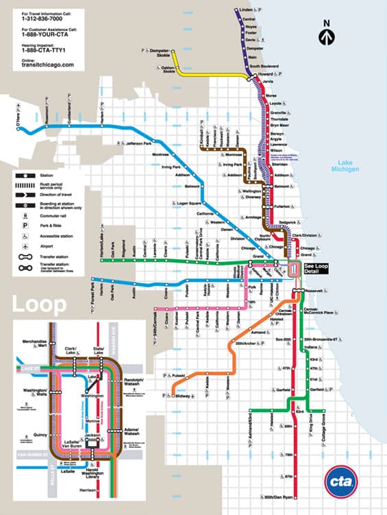
Created in 1947 by the Illinois state legislature, the CTA provides and regulates the public transportation within Chicago and into many of the nearby suburbs. It is the second-largest system of public transit in the nation behind New York City’s, with over 1.5 million bus and train commuters daily. During rush hours Chicago’s streets and expressways are often congested to the point of standstill, making public transportation a more viable option.
CTA train lines include over 200 miles of railway and 140 stations, and run from the city center to the north, south, and west sides of the city. Both O’Hare and Midway airports are accessible by the Blue and Orange Lines, respectively. Many trains run late into the night; the Red and Blue lines run 24 hours a day. Bus routes help fill the gap in areas with limited rail access—more than 150 bus routes operate daily in the city, covering more than 2,200 miles of road.
Chicago’s accessible public transportation has been a major factor in the city’s continued growth. The CTA alone has created many jobs and several businesses have developed to take advantage of their proximity to CTA train stations and bus routes. The CTA has proven invaluable to the daily lives of city residents, many of whom do not require cars because of the convenience of public transit services. If you’re a visitor or a new resident of the city, you’ll no doubt become quickly accustomed to using the CTA for many of your travel needs.
If you need to reach your Dream Town Broker or have a general question, please call 312.265.8000 or email us.
If you have questions about a property, please call 312.278.2000.